The CRL, Singapore’s eighth MRT line, is a 50km long project and fully underground. It will serve existing and future developments in the eastern, western, and north-eastern corridors. It will link major hubs such as Jurong Lake District, Punggol Digital District and the Changi region. When fully completed, the CRL is expected to have a daily ridership of at least 600,000 in the initial years, growing to one million in the long term. The CRL will have almost half of its stations as interchanges with other train lines, making it easier and more convenient to travel across the rail network. It will be constructed in three phases.
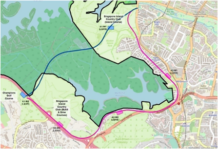
After in-depth studies of both alignment options, the Government has decided to adopt direct alignment for the stretch of the Cross Island Line in the vicinity of the Central Catchment Nature Reserve (CCNR). In reaching this decision, the Government has considered various factors, including the concerns expressed by all stakeholders and the findings of the comprehensive two-phased Environmental Impact Assessment (EIA). The reports for the two EIA phases were shared with the public in 2016 and 2019 respectively.

Direct (blue line) and Skirting (pink line) alignment options
CCNR boundary marked by black line
CRL1 is 29 km long and comprises 12 stations from Aviation Park to Bright Hill (working names). This will serve residential and industrial areas such as Loyang, Tampines, Pasir Ris, Defu, Hougang, Serangoon North and Ang Mo Kio and benefit more than 100,000 households. With CRL1, common recreational spaces such as Changi Beach Park and Bishan-Ang Mo Kio Park will be more accessible by public transport. Studies on the details of subsequent CRL phases are ongoing. For further information please click here and sg/30 for the tunnelbuilder archive. 10/21.

